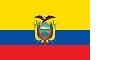

This site is about one of the Countries that lies on the Equator. The Country of Ecuador, or more correctly the República del Ecuador, which literally translates as “Republic of the Equator“ The flag is similar to Colombia and Venezuela, with the addition of this very symbolic coat of arms.
The territories of modern-day Ecuador were once home to a variety of Amerindian groups that were gradually incorporated into the Inca Empire during the 15th century. The territory was colonized by Spain during the 16th century. It became independent from Spain in 1820 as part of a larger region called Gran Colombia, but then became its own sovereign state ten years later in 1830.
The legacy of both the Inca and the Spanish empires is reflected in Ecuador’s ethnically diverse population. Most of its 17.1 million people are of Mixed Race (mestizos), but there are also large minorities of European, Native American, and African descendants.
Spanish is the official language and is spoken by a majority of the population, although a further 13 Native languages are also recognized, including Quechua and Shuar.

If your not familiar with the Geography of South America, you will see Ecuador is a small country on the west side.
It is on the Pacific Ocean, with land borders with Colombia and Peru. The Inca Empire stretched from Colombia, through Ecuador and Peru, with some of Bolivia and half of Chile. When independence came from the Spanish, for ten years, Colombia, Ecuador and Peru were once one country called “Gran Colombia” in the 18th Century.
Today Ecuador divides nicely into four main geographical regions (as shown on the map)
- Coast (or costa) – mainly green area on the left of the map
- High Andes Mountains (or Sierra) – mainly brown area in the middle of the map
- Jungle (or Amazonia) – mainly yellow area on the map
- Islands (or Galapagos) – 563 miles west of mainland Ecuador – in the separate box.